The clean energy transition to net zero by 2050 requires a six-fold increase in the supply of critical metals (IEA 2021a). Securing this supply is at risk due to the deteriorating quality of metal-bearing deposits, their concentration in geopolitically challenging jurisdictions and concerns over the environmental, social and governance (ESG) impacts of mining on land. Seafloor polymetallic nodules in international waters contain abundant quantities of several important critical metals (nickel, copper, cobalt, manganese) and could be developed into a new source of supply under international regulatory oversight and in compliance with stringent ESG standards (Hein 2020). Given the scale of this resource, how much seafloor would a potential nodule collection industry disturb?
Seafloor with potential to host nodules
Polymetallic nodules were first discovered on the seafloor at 4,300–5,500 m depths during the 1872–1876 research voyage of the HMS Challenger. They tend to form under a specific set of geological and oceanographic conditions that are present in the areas marked in blue on the map below (Hein et al 2020). But just because an area is marked in blue does not mean that the entire area is blanketed by nodule fields or that the nodules present are of economic interest.
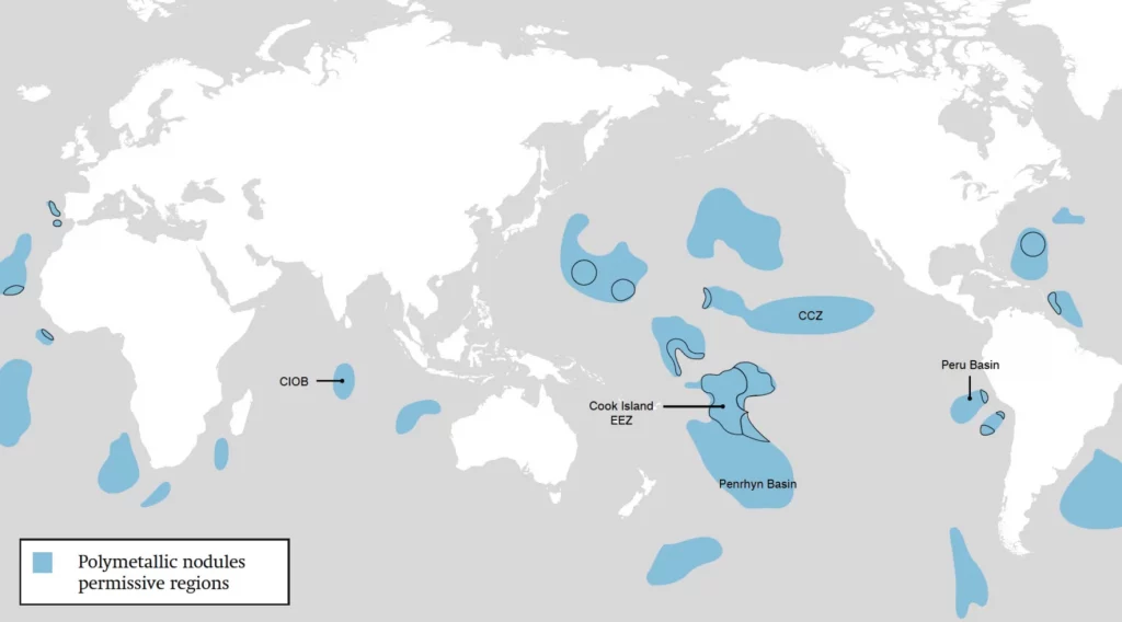
Not all nodules are created equal. They form on the seafloor sediment around a nucleus through the precipitation of metals dissolved in the seawater and in sediment pore water. What metals and in what quantities are present in the water depends on what geological formations are nearby. Some nodules are mostly iron and manganese–essentially cannon balls–and are not of economic interest. The four best known polymetallic nodule deposits are the Clarion–Clipperton Zone (CCZ), Peru Basin, Penrhyn Basin (including the Cook Islands EEZ) and Central Indian Ocean Basin (CIOB).
Protected vs. exploration areas
The first two predictors of the size of the area that could be commercially developed are protected areas and exploration areas. Some of the seafloor will never be touched because it has been or will be set aside into protected areas. The global target championed by the High Ambition Coalition for Nature and People, a United Nations initiative, is to protect at least 30% of the world’s land and ocean by 2030 (known as 30×30) to halt the accelerating loss of species and protect vital ecosystems (HAC 2022). For the residual seafloor area, the best predictor of whether a nodule field could be one day commercially developed is whether a given area is under an exploration contract today. An exploration contract means that a contract-holder is spending money and effort to define the resource and figure out how much of the defined resource could be extracted economically and at an acceptable environmental cost.
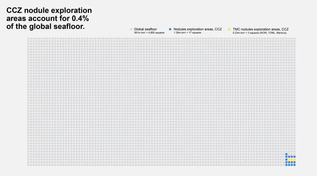
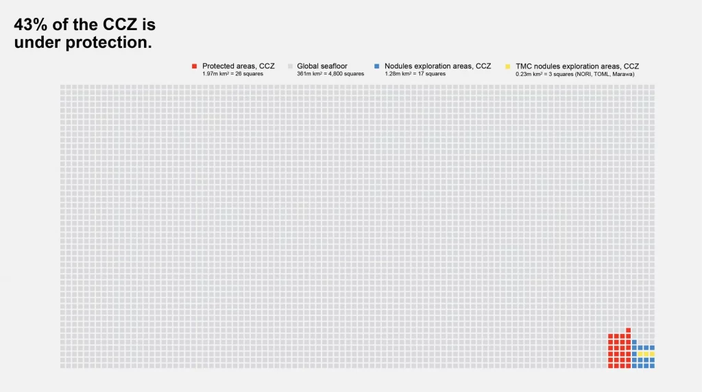
The CCZ is a 4.5 million km2 area and it accounts for 90% of the nodule deposit exploration activity in the international waters today. In the CCZ, the International Seabed Authority (ISA) has already set aside 43% or 1.97 million km2 into protected areas–exceeding the 30×30 goal–and has granted 17 nodule exploration contracts covering the total area of 1.28 million km2 (ISA 2022), or 0.4% of the global seafloor.
Outside of the CCZ, the ISA has granted only two other nodule exploration contracts: one in the CIOB and one in the Western Pacific Ocean, accounting for an additional seafloor area of 0.15 million km2 (ISA 2022).
Outside international waters, only one government has granted nodule exploration contracts in their EEZ to date: the Cook Islands awarded three exploration contracts covering the total seafloor area of 0.25 million km2 (Cook Islands 2022).
This brings the seafloor area under exploration globally to 1.68 million km2, with CCZ accounting for 76% of this total.
Sizing up the future nodule collection industry
If all current nodule exploration contract holders decided to exploit 100% of their current exploration areas over a 30-year period (typical length of mining licenses) and they all started operations on the same day, then the total seafloor that would be impacted by the nodule collection industry would be 56,000 km2 per year (1.68 million km2 / 30 years). This gives us a theoretical upper limit on the seafloor area that could be impacted annually.
In reality, this seafloor use is highly unlikely because not all contractors will proceed from exploration to exploitation. Those who will proceed will have to leave parts of their original exploration areas untouched for several reasons. These untouched parts would include (1) areas that have no nodules or not enough nodules to justify commercially viable extraction, (2) areas where the seafloor is too steep to be traversable by nodule collection machines, and (3) areas set aside by contractors as preservation reference zones and zones to ensure habitat connectivity that could help the recovery of seafloor areas impacted by nodule collection. If you consider all these exclusions, it would not be unreasonable to expect that the more realistic seafloor footprint of the industry would be around 50% of the theoretical upper limit, or 28,000 km2 per year.
Is 28,000 km2 per year a lot? The answer depends on the basis for comparison. If we look at some of the current uses of the global seafloor, industrial trawling and dredging has been estimated to impact 4,900,000 km2 every year (Sala et al 2021), or 175 times more seafloor area than our estimate for the annual footprint of the nodule collection industry. Importantly, nodule collection is a one-off impact: once nodules have been picked up, nodule collection vehicles move on leaving the seafloor to recover. In contrast, industrial trawling and dredging is a recurring activity that can impact the same area year after year, usually in highly productive EEZs which currently provide 96% of global catch and contain most of the world’s overexploited fisheries (Goni 2011). Furthermore, trawling disturbs carbon-containing seafloor sediment that can re-mineralize sedimentary carbon to CO2 (likely increasing ocean acidification), reduce the buffering capacity of the ocean and potentially add to the build-up of atmospheric CO2 through reduced buffering and upwelling (Sala et al 2021). Nodule collection in the abyssal plains at 4-6 km depth and far offshore in low-productivity parts of the ocean are not expected to impact food provisioning and although operations would disturb carbon-containing seafloor sediment, there are no known mechanisms for this disturbance to impact CO2 contents of our atmosphere (Paulikas et al 2020).
What about the seafloor used for offshore wind farms? Net zero by 2050 requires 1,260 GW of offshore wind capacity globally (IEA 2021b). This capacity would need a seafloor footprint of about 415,000 km2 (Net-Zero America, 2021), or about 15 times more than the seafloor area that would be likely impacted by the future nodule collection industry every year. Some envision an even more aggressive deployment of offshore wind predicting 5,800 GW of capacity by 2050 (GWEC 2016) which would increase associated seafloor use five-fold. Unlike nodule collection, offshore windfarms are not a one-off impact but permanent infrastructure that would remain on the seafloor for the life of the farm, possibly for several decades.
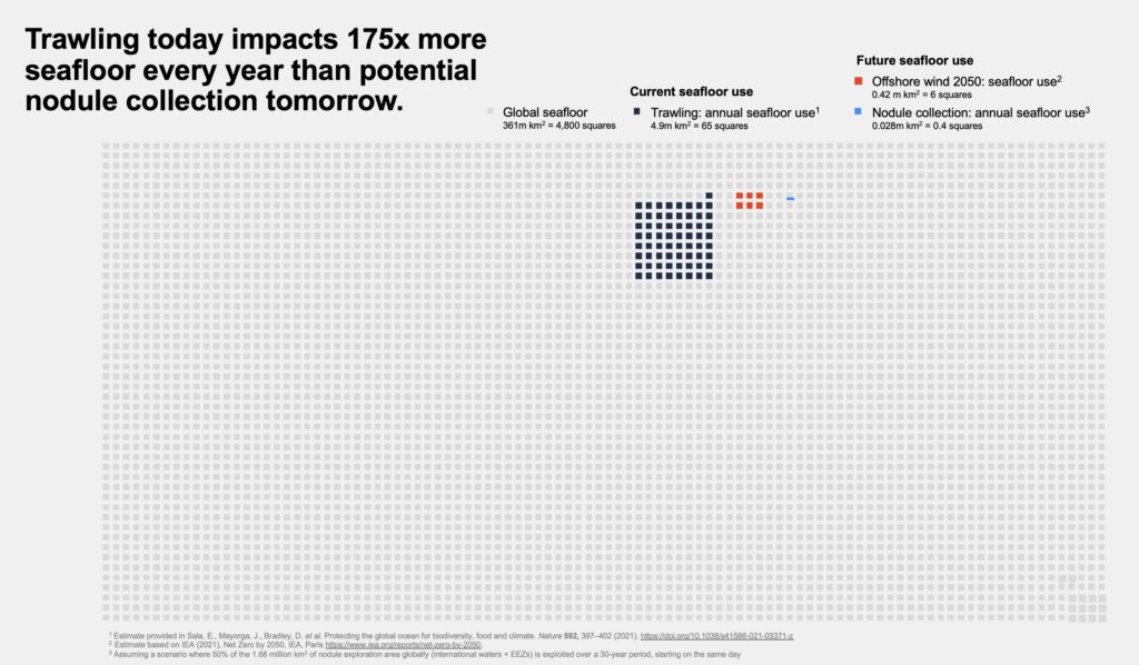
The future nodule collection industry is likely to impact no more than 0.008% of the global seafloor every year—a barely visible area on the global seafloor visualization above. This seafloor disturbance is expected to be three orders of magnitude smaller than current use of the seafloor by industrial trawling and dredging and up to an order of magnitude smaller than the expected seafloor footprint of offshore wind required to get to Net Zero by 2050.
References
Cook Islands’ Seabed Minerals Authority: Map of 2020/2021 Exploration Applications, retrieved on 6 April 2022. https://www.sbma.gov.ck/moana-minerals-ltd
Global Wind Energy Council (GWEC 2016), Global Wind Energy Outlook 2016. https://gwec.net/gwec-envisages-5-8tw-of-wind-by-2050/
Goñi, R., Badalamenti, F. & Tupper, M. H. in Marine Protected Areas: A Multidisciplinary Approach (ed. Claudet, J.) 72–98 (Cambridge Univ. Press, 2011).
High Ambition Coalition for Nature and People: Why 30×30? retrieved on 6 April 2022. https://www.hacfornatureandpeople.org/why-30×30
Hein, J.R., Koschinsky, A. & Kuhn, T. Deep-ocean polymetallic nodules as a resource for critical materials. Nat Rev Earth Environ 1, 158–169 (2020). https://doi.org/10.1038/s43017-020-0027-0
IEA (2021a), The Role of Critical Minerals in Clean Energy Transitions, IEA, Paris https://www.iea.org/reports/the-role-of-critical-minerals-in-clean-energy-transitions
IEA (2021b), Net Zero by 2050, IEA, Paris https://www.iea.org/reports/net-zero-by-2050. This report contains a reference to IEA Offshore Wind Outlook 2019 that projects 560 GW offshore wind capacity by 2040. The Net Zero by 2050 report estimates a growth rate of 70GW offshore wind per year between 2030 and 2050, implying a capacity of 1,260 GW by 2050.
ISA Polymetallic Nodule Contractors, retrieved on 6 April 2022. https://isa.org.jm/exploration-contracts/polymetallic-nodules
ISA Report of the Chair of the Legal and Technical Commission on the work of the Commission at its twenty-sixth session: Decision of the Council of the International Seabed Authority relating to the review of the environmental management plan for the Clarion-Clipperton Zone, 10 December 2021, ISBA/26/C/58